
Rare Maps

Rare Atlases

Rare Books

Rare Prints

Daniel Crouch Rare Books publishes a number of catalogues each year, focusing on rare maps, antique atlases, globes & planetaria, antiquarian books, fine prints and other works on paper. These range from deluxe printed catalogues of single-owner collections and interactive online catalogues to specialised digital short-lists and exhibition lists for the numerous specialist events relating to rare maps and books that we attend throughout the year, around the world.
From here, you can download or, where applicable, purchase our catalogues directly. For more information on our past catalogues, or if you have a collection you would like to see brought to market in a similar fashion, please contact us.
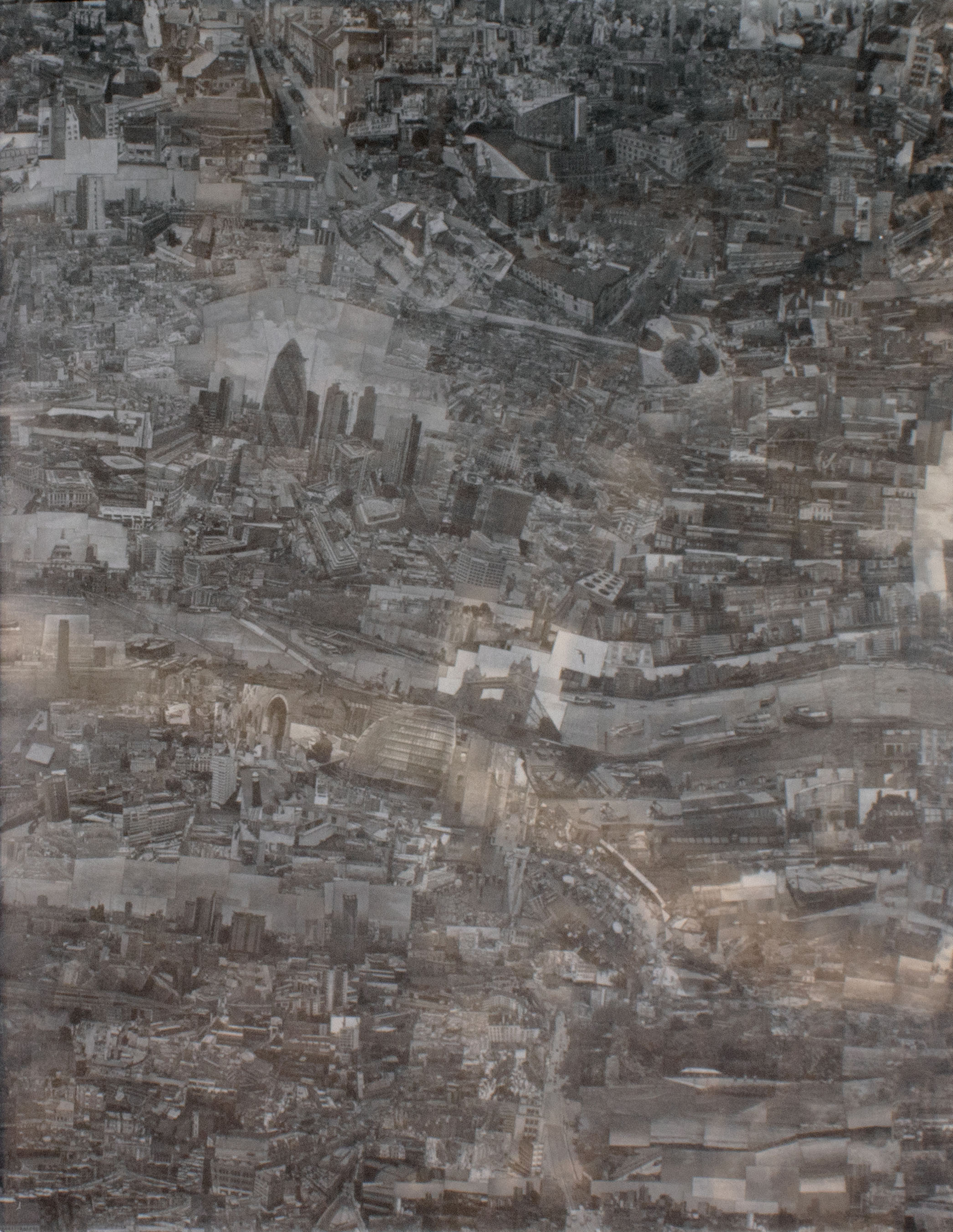
Cities, like people, are full of contradictions. They promise order but grow through chaos. They are built on careful plans, yet shaped by imagination and memory. Cities, like dreams, a collaboration between Daniel Crouch Rare Books and Michael Hoppen Gallery for TEFAF Maastricht 2026, explores how cities have been pictured and understood across three centuries - how they have been drawn from above and experienced from within.
The exhibition brings two very different ways of seeing together. Monumental eighteenth‑century town plans - made at a time when faith in reason and measurement was at its height - are shown next to Sohei Nishino’s large‑scale photographic dioramas, dreamlike reconstructions of the same cities created from thousands of individual photographs. These pairings reveal what the city has always been: both a system and an emotion, something that can be mapped and yet never truly contained.

We are delighted to present The Roger Cline Collection - The story of London told in 40,000 books, maps, and prints spanning 400 years - the largest such collection in private hands.

Rosie and David Temperley believe that “communication, cooperation, and creativity” are the three key tenets for social cohesion, and life.
The Temperley Collection, their vast accumulation of books and ephemera, acquired over more than sixty years, is a blinding reflection of this bright ideal, illuminated via the ingenuity of a myriad of papery arts. The result is a cornucopia of marvels and delights that (literally) spring, bounce, twist, turn, fold, flap and flip – off, on and through the pages of thousands of books, cards, prints, and toys.
Over the course of the 500 years that the Temperley Collection spans, some of the most enlightened minds have used these methods to communicate the scientific and religious mysteries of our heavens and earth. Above all, the Temperley Collection practices what it preaches: it is a library that refuses to stay put on the shelves; it is an experience which demands immersion and participation.

The discovery and exploration of Australia has long been framed as both an act of chance and of growing curiosity, shaped by the vast seas of the southern hemisphere and guided by the faint patterns of the stars.
The 111 maps and books of the Michael and Wendy Brown Collection tell this story from the creatures of ancient European myth, via the monsters of colonialism, to the behemoth of globalisation and modern multi-cultural Sydney.

Since early modern times, the artistic, printing and publishing world, including cartography, has on occasion, provided women with a means of agency, expression, and visibility. The women cartographers in this selection have, against the odds, been able to publicly claim their work.

It is with great pleasure that Altea Gallery and Daniel Crouch Rare Books bring you this joint catalogue of the manuscript and printed archive of the world-renowned maritime chart publisher Imray, Laurie, Norie and Wilson Ltd.
The collection is a unique portrait of the Enlightenment world at the turn of the eighteenth century.

Daniel Crouch Rare Books is proud to present a collection of playingcards and related items that are a store of artistic, political, industrial and cultural history spanning seven centuries and five continents. These palmsized pieces of paper have the power to enrich, educate, advertise or entertain.
The artistic and technical innovations of the generations of card-makers represented here have ensured that, even if you get dealt a bad hand, you are still holding good cards.

Whether alone or in teams, for pleasure or profit, sporting or seated, games have been an ever-present feature of every civilization. During the eighteenth century, not only were industrial advances making large-scale printing easier, but they were also generating something that had never before been available to the majority of society: leisure time. Paired with growing literacy rates across society and greater understanding of the importance of childhood education, this gave birth to a wave of new and unique games, especially in the form of jigsaw puzzles, playing cards, and board games.

If journalism is, as they say, the first draft of history, then perhaps photography is the raw material of memory; in the sense not just of personal mementoes (though that’s often the way photographs start out), but also of shared recollection. And that sort of collective remembering is, in turn, the stuff of history’s sister, culture, and of identity.

Maps are scientific instruments. They offer proof of truth. They portray measured relationships between objects and ideas. To achieve this, however, maps must reduce, omit, and distort a three-dimensional world onto a flat piece of paper. This is the paradox of cartography: to tell the truth, a map must lie.

In antiquity, the earliest geographers and cartographers hypothesised a southern landmass to balance out the northern hemisphere, and when, in the second century, Ptolemy asserted that the Indian Ocean was bounded by land to the south, the legend of a terra australis incognita was born.

The Commonwealth of Dominica. The Nature Island. Wai’tu kubuli, which, in the language of the indigenous Kalinago Indians, translates as ‘Tall is her body’. This collection, assembled over two generations, portrays Dominica through one hundred maps, prints, books, manuscripts, and ephemera.

Three thousand years of history, geography, religion, and politics in one thousand maps, plans, and books. There exists a deep-rooted affinity between the history of cartography and the history of the Holy Land. The region served as the subject of the very first survey recorded in writing (Joshua 18:4) and continued to play a prominent role in cartography throughout the following millennia. Please note that shipping is not included. Costs are: £25 to the UK, £35 to Europe, and £45 to the rest of the world.

“There is nothing in the world of fine books quite like the first discovery of Audubon. The giant energy of the man, and his power of achievement and accomplishment, give to him something of the epical force of a Walt Whitman or a Herman Melville. … Audubon is the greatest of bird painters; he belongs to American history, and as a writer he described things that human eyes will never see again” (Sitwell)

“Every hand’s a winner!” - A catalogue of 57 decks of playing cards from c1630-1991, including a pack unknown until 2016, a gorgeous set of embroidered silk brocade cards, Ganjifa cards, and several English seventeenth century decks.

Our latest catalogue offers a very select group of the earliest, the most important, and fiendishly rare, maps, atlases, and travel accounts, which are the first printed attempts by European commentators and adventurers, to depict their world, and the emerging outline of the Americas.

‘From Sea to Shining Sea’, the Petros G. Pelos Collection of exceptionally rare first-hand printed and manuscript travel accounts, atlases, portfolios, and governmental proclamations. Offered together as a single entity, these 100 items not only reflect the emerging shape of the United States, from the end of the Revolutionary War to the beginning of the Civil War, but were fundamentally instrumental in creating its identity.

A cartographic voyage across time and space.

The William B. Ginsberg collection of World Maps; an epitome of the most beautiful, powerful, and influential cartographical images of the 15th and 16th centuries. The earliest printed maps condensed and edited information from three “traditions” of map-making: Christian iconography, classical cartography, and contemporary charts. Ginsberg’s collection encapsulates the subtle metamorphosis of this amalgam of art and science, myth and metaphor, discovery and design, in nineteen maps: from the world map of the ‘Rudimentum novitiorum’ (1475), the earliest printed map, in magnificent original hand-colour; to the largest Italian world map published in the 16th century, Giuseppe Rosaccio’s ‘Universale Descrittione di Tuto il Mondo’ (1657).

Playing cards is, in many ways, a hallmark of civilisation. Like maps and money, a deck of cards is a way of representing an entire value system and an understanding of human nature on paper. A game of cards embodies the inherent unpredictability of life, allowing us to grapple with the uncertainties, directing them towards our own ends. At the card table, when the hands are dealt, all men are temporarily equal; it is how they choose to play those cards that determines who will draw ahead. The players are required to practice both strategic and emotional discipline, and one’s reaction to a bad hand or a sudden windfall can reveal much about his temperament and priorities. As in cards, so in life.

A new catalogue focusing on celestial cartography, a selection of items that show how humans have charted the heavens and marked time by the light of the stars for over 500 years.

We are delighted to present our latest catalogue: Hollar - comprising a single-owner collection of works by the master etcher: from maps, topographical views, and architectural drawings, to portraits, records of the latest fashion, and studies of animals.

A new catalogue focusing on London, including a selection of Frost Fair prints, large-scale plans of London boroughs, and the first printed depiction of Elizabeth I as queen.

Popular from the end of the seventeenth century in London and Paris, trade cards performed the dual functions of advertisements and maps, directing the public to the merchants’ stores – often with rambling descriptions to help locate the business in an era where formal street address numbers were rare. Trade cards were sufficiently small so that they could be carried in the gentleman’s pocket or lady’s purse.

Ten years in the making, this collection of cartographic ephemera - including advertisements, catalogues, manuscript correspondence, portraits, price lists, and trade cards - physically illustrates the struggles, exchanges and e orts of some of the leading gures of the map trade over the past five centuries.

The world’s obsession with discovering the exotic source of cinnamon and other elusive spices grew throughout the Roman era and into the medieval period, defining what it meant to be wealthy and powerful. From India to Europe the trade had a profound social, emotional and economic impact; giving rise to some of the first truly international trade routes, and shaping the structure of the world economy in a way that can still be felt today.

A magnificent portolan atlas by Battista Agnese in its original binding, inscribed and attributed to Agnese by the eminent bibliographer Henry Harisse.

The globes within these pages are far more than guides to geography and astronomy; they offer a glimpse into history. Observe how land, sea and stars shift over the course of 500 years, as human endeavour and ingenuity gradually uncovered more about the world around us.

An unique, 20 volume monumental grand composite atlas in magnificent condition, compiled by Pierre Jean le Mire (d1753), Canon of the Collegiate Church of Saint Vincent de Soignies in Hainaut.

Our first bilingual catalogue, and the first dedicated to China: The Middle Kingdom 中國. The catalogue presents an eclectic collection of maps, charts and books related to China spanning the thirteenth to twentieth centuries, reviving different perspectives of Chinese scholars and cartographers, Jesuit missionaries and representatives of the British Empire

The catalogue examines the role of pirates, privateers, buccaneers and freebooters in the tumultuous relationships between European countries as they expanded their trade and territories beyond their borders.

The eighteenth century baroque town plan. The collection comprises massive wall maps of Amsterdam, Berlin, London, Madrid, New York, Paris, Rome, St Petersburg and Venice.

Daniel Crouch Rare Books is pleased to present our catalogue of the Jason C. Hubbard Collection. Jason Hubbard bought his first map in 1971. Since then, he has built up a collection of material relating to Japan, including not only maps of Japan, but also maps of the continent and neighboring countries, sea charts, and books and travel accounts. Because of the considerable breadth of the collection, the catalogue is split into three parts: pre-1800 maps of Japan; post-1800 maps of Japan and sea charts; maps of Asia, China and Tartary, the East Indies, regional maps of Japan and books.

“The cause of America is in a great measure the cause of all mankind” (Thomas Paine, ‘Common Sense’, 1775-1776). Welcome to catalogue XV, published to coincide with the first anniversary of the opening of our shop in New York; hence the distinct American flavour - or should we say flavor - with almost a third of the items pertaining to the New World.

“There are three kinds of lies: lies, damned lies, and statistics”

A collection of English pocket globes from the long eighteenth century.

The earliest printed maps condensed and edited information from three “traditions” of map-making: Christian iconography, classical cartography, and contemporary charts.

In this catalogue we have selected 28 items – one for each of the states of the current European Union – that explore the history and idea of the European nation state. In his introductory essay Professor Colin Crouch argues that territorial sovereignty is rooted more in political expediency than in natural borders or cultural identity. Advances in mapmaking technologies not only preceded the birth of the modern European nation state, but were also necessary conditions for its creation.

The 1531 planisphere signed and dated by Vesconte Maggiolo is a remarkable survival: a monumental early sixteenth century portolan chart of the known world, in astonishingly good condition, with rich decoration, vibrant colours, and heightened in lapis lazuli, gold, and silver.

We are pleased to announce the publication of Catalogue IX, released for both the opening of our New York gallery and the inaugural TEFAF fair in New York. Fittingly, many of the items in the catalogue deal with new frontiers, from a copy of the terms of Columbus’s journey to America to a globe showing one woman’s plans for a socialist utopia on Mars.

In 2011, Daniel Crouch Rare Books produced a catalogue of maps showing London from 1574 to the present day. In 2016, we return to the capital, but this time, with a catalogue of prints.

Welcome to Catalogue VII, published on our fifth anniversary. To mark this occasion we have selected from our inventory the most spectacular examples in each of the fields in which we specialise – atlases, maps, globes, voyages, and scientific instruments. Each item is distinguished by its historical interest, rarity, or beauty. The most exceptional combine all three, like the pair of Blaeu globes made for Schloss Baldern in Germany (item 46). All represent pinnacles of human achievement, created by the most gifted scholars and craftsmen of their time.

Catalogue VI represents something of a departure for Daniel Crouch Rare Books. In the year that marks 300 years since the passing of the Longitude Act, and the 25th anniversary of the World Wide Web, we thought it a good time to put together a collection of calculating machines from the first information revolution.

Welcome to the fifth catalogue from Daniel Crouch Rare Books. The catalogue comprises a selection of the items that we will be exhibiting at the 26th European Fine Art and Antiques Fair in Maastricht and, as a consequence, it has an undeniably Dutch feel about it.

In celebration of The European Fine Art Fair’s 25th anniversary, we areproud to present 25 spectacular items from the first four hundred years of the history of printing.

Welcome to the third catalogue from Daniel Crouch Rare Books. Within these pages you will find 100 plans showing London’s rapid development, from the Tudors to the Windsors. You will see London the glutton, purged by fire, the home of the rich as well as the poor, and a refuge and opportunity for strangers; a city not dissimilar to the one we inhabit ourselves.

For our second catalogue, we are proud to present a selection of rare and important atlases, sea atlases, wall maps, manuscript maps, and voyages.

For our inaugural catalogue we are proud to offer the Gestetner Collection of maritime atlases and voyages. Undoubtedly one of the best libraries of sea atlases in private hands, the books are remarkable both for their exceptional quality and their rarity. The Gestetner family started building a collection of maritime atlases and voyages twenty years ago to celebrate their love of sailing and the many happy times they had spent together on their various boats, all named ‘Grumpy Skipper’.