 Rare Maps
  Rare Atlases
  Rare Books
  Rare Prints
  Globes and Planetaria
 Sign up to hear about our latest acquisitions, exhibitions and events


Find Us
New York
PO Box 329, Larchmont, NY, USA
Opening hours, London Gallery
Monday to Friday: 10:00 – 18:00
Saturday: by appointment
Closed: all bank holidays and 1-31 August
Opening hours, New York
By appointment only
Opening hours

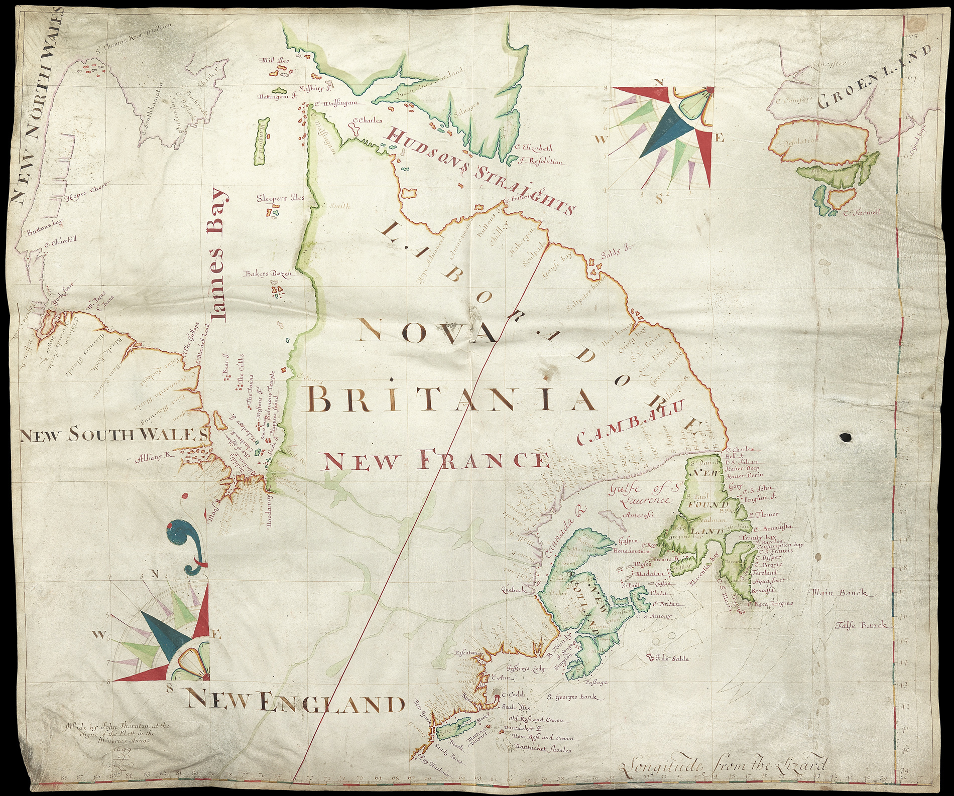
[Manuscript map of North America].
- Author: THORNTON, John
- Publication date: 1699.
- Physical description: Manuscript, pen and ink on a single sheet of vellum showing the north east cost of America from Hudson's Straights through Labrador and Newfoundland to New England and New York.
- Dimensions: 680 by 800mm. (26.75 by 31.5 inches).
- Inventory reference: 1184
Notes
John Thornton was the main supplier of maps to the Hudson’s Bay Company (HBC) in the latter part of the seventeenth and early eighteenth century. He drafted and delivered 10 to 11 maps and charts to the company between 1680 and 1702. Unfortunately none of these maps survived in the company’s archives, although there is evidence of his various commissions for the HBC in the records, including an item in the Governor and Committee minutes for 1700 that HBC purchased two “mapps of Hudson’s Bay” (likely based on this 1699 map). These maps were used by the HBC to illustrate its claims and assert its rights over its domain in North America. The minutes of 1700 also record that the French were insisting on a boundary extending across James Bay at 52° 30′ north latitude, with their ownership confirmed to the south of this line. HBC countered with a line running along what is represented to be the Hudson-James Bay watershed through Lake Mistassini, northeast to the Labrador coast just south of 60° North Latitude. The boundary line “in red” asserted by HBC appears on this map.
The HBC Archives holds two similar maps of Hudson’s Bay produced in 1709 by John Thornton’s son, Samuel Thornton, who took over his father’s map making business. John Thornton’s map of 1699 appears to have been used as a template for these maps. The 1709 maps were used during the negotiations that led to the Treaty of Utrecht in 1713. More recently, the maps were used as evidence during the 1927 Labrador boundary dispute between Canada and Newfoundland which established the border between Quebec and Labrador.
The map is constructed very similarly to the Thornton maps in HBC Archives’ holdings in terms of both their materials: vellum and mark making media (i.e. inks, paint, colourants); and the application of the media (i.e. full strength colour and wash combinations).
The map created by John Thornton in 1699 is discussed by Dr. Richard Ruggles in ‘A Country So Interesting: The Hudson’s Bay Company and Two Centuries of Mapping’, 1670-1870 p. 26 (see below).
Thornton was paid £3 for the delivery of two “mapps of Hudson’s Bay” to the secretary, the minutes of 4 October 1700 record (A1/22,fo.19). As the only known Thornton map of this area at this time is one for 1699, these two copies were probably prepared by him in that year. Evidence for this is found in the minutes of a series of meetings of the general court of the company from 10 May 1700 to 29 January 1701, at which France’s territorial claims in north America were discussed (A2/1, fos 19-21). The French were disputing the company’s proprietorship of all the shores and immediate territory of Hudson and James bays. The French insisted on a boundary extending across James Bay at 52°30′ north latitude, with their ownership confirmed to the south of the Albany, Moose, Rupert, and Eastmain rivers. In rebuttal, the company claimed its charter rights in presenting its claims to the officials of the government and to William III (to the latter in a petition). At least on two occasions, when these matters were discussed with the Lords Commissioners of Trade and Plantations, the company representatives took along a “Mapp of Hudsons Bay.” The two copies of this map may have been taken by the committee to a meeting with the Lords Commissioners on 12 June 1700 and on one other occasion to be used as evidence during the discussions. In any event, the copies were probably of the 1699 map; on it, a line running along what was represented to be the Hudson-James Bay watershed through Lake Mistassini, north-east to the Labrador coast just south of 60° North latitude, illustrated the company’s claim. There is a possibility that one of the maps may have been included with the company’s petition to King William, and the other may have accompanied a paper concerning the national limits in the bay, “according to Mr Secr Vernons desire”(A1/22, fo. 17).
Provenance
From the estate of Harold Fortington, Glennie, Aberdeenshire.
Related items


Sign up to hear about our latest acquisitions, exhibitions and events
Find Us
New York
PO Box 329, Larchmont, NY, USA
Opening hours, London Gallery
Monday to Friday: 10:00 – 18:00
Saturday: by appointment
Closed: all bank holidays and 1-31 August
Opening hours, New York
By appointment only