 Rare Maps
  Rare Atlases
  Rare Books
  Rare Prints
  Globes and Planetaria
 Sign up to hear about our latest acquisitions, exhibitions and events


Find Us
New York
PO Box 329, Larchmont, NY, USA
Opening hours, London Gallery
Monday to Friday: 10:00 – 18:00
Saturday: by appointment
Closed: all bank holidays and 1-31 August
Opening hours, New York
By appointment only
Opening hours

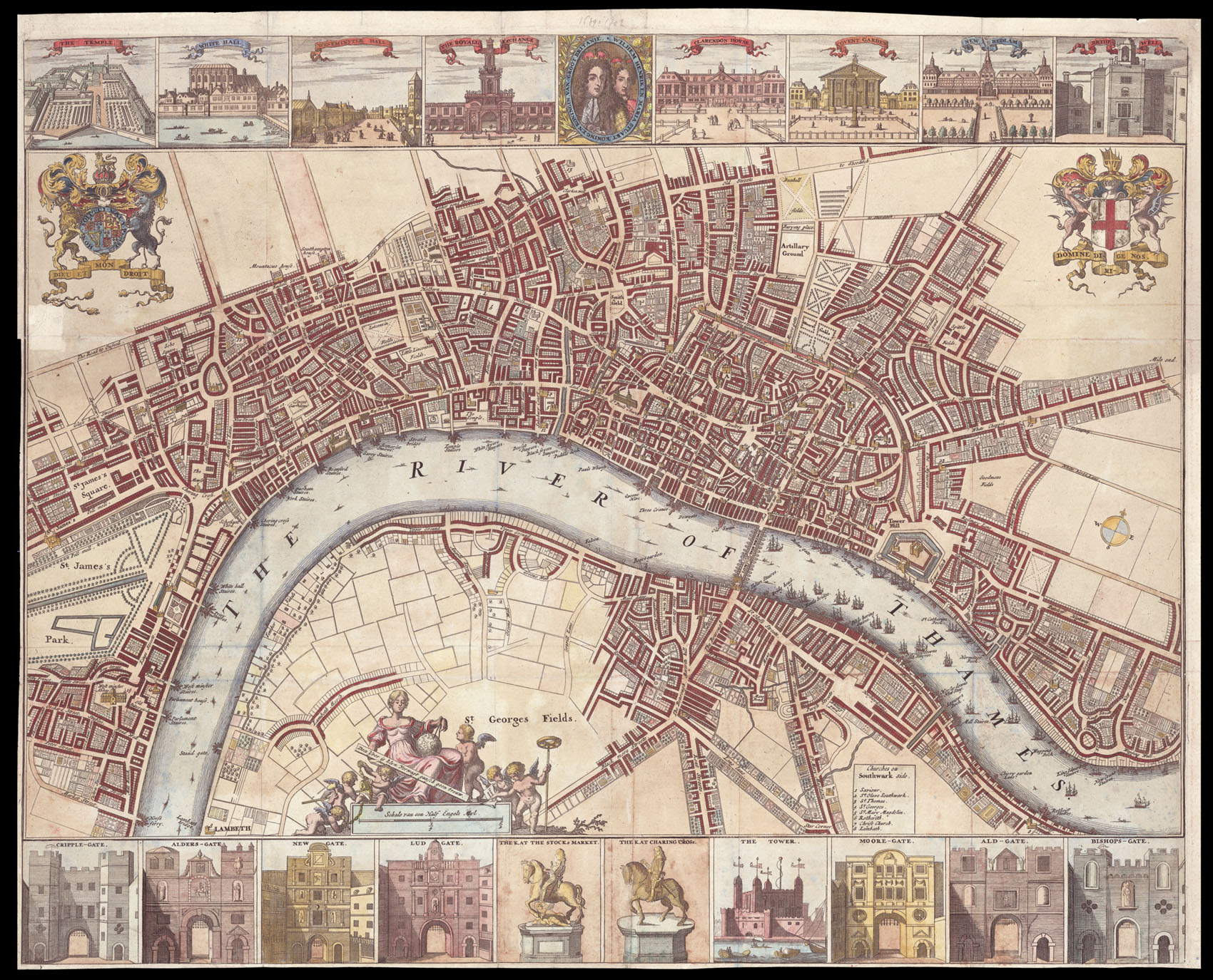
[London].
- Author: ANONYMOUS
- Publication place: [?Amsterdam
- Publication date: c. 1690].
- Physical description: Hand-coloured engraved plan, with 18 inset views of major public buildings, gates, and statues, a few nicks and tears skilfully repaired.
- Dimensions: 485 by 595mm (19 by 23.5 inches).
- Inventory reference: 1513
Notes
This highly detailed plan extends from Westminster in the west to Wapping in the east and Clerkenwell in the north to St. George’s Fields in the south. The most important public buildings are depicted in elevation, including the Tower of London, Westminster Abbey, and St Paul’s. Several places are marked with letters and numbers. To the left of St George’s Field is a reclining female, with a globe and pair of compasses; she sits upon the scale bar and is surrounded by putti holding surveying tools. To the upper left and upper right are the royal and City of London coats-of-arms respectively. Above and below the plan are eighteen views of public buildings, gates, and statues; they are from upper left to lower right: The Temple (Temple Bar), Whitehall, Westminster Hall, The Royal Exchange, Clarendon House, Covent Garden, New Bedlam, Bridewell, Cripple-gate, Alders-gate, Newgate, Ludgate, Statue of Charles II at the Stocks Market, and Charles I at Charing Cross, The Tower of London, Moore-gate, Ald-gate, and Bishops-gate. Also along the upper border is a cameo of William and Mary.
Scale: approx. 6 inches to 1 statute mile.
Bibliography
- Howgego 39.
Related items


Sign up to hear about our latest acquisitions, exhibitions and events
Find Us
New York
PO Box 329, Larchmont, NY, USA
Opening hours, London Gallery
Monday to Friday: 10:00 – 18:00
Saturday: by appointment
Closed: all bank holidays and 1-31 August
Opening hours, New York
By appointment only