 Rare Maps
  Rare Atlases
  Rare Books
  Rare Prints
  Globes and Planetaria
 Sign up to hear about our latest acquisitions, exhibitions and events


Find Us
New York
PO Box 329, Larchmont, NY, USA
Opening hours, London Gallery
Monday to Friday: 10:00 – 18:00
Saturday: by appointment
Closed: all bank holidays and 1-31 August
Opening hours, New York
By appointment only
Opening hours

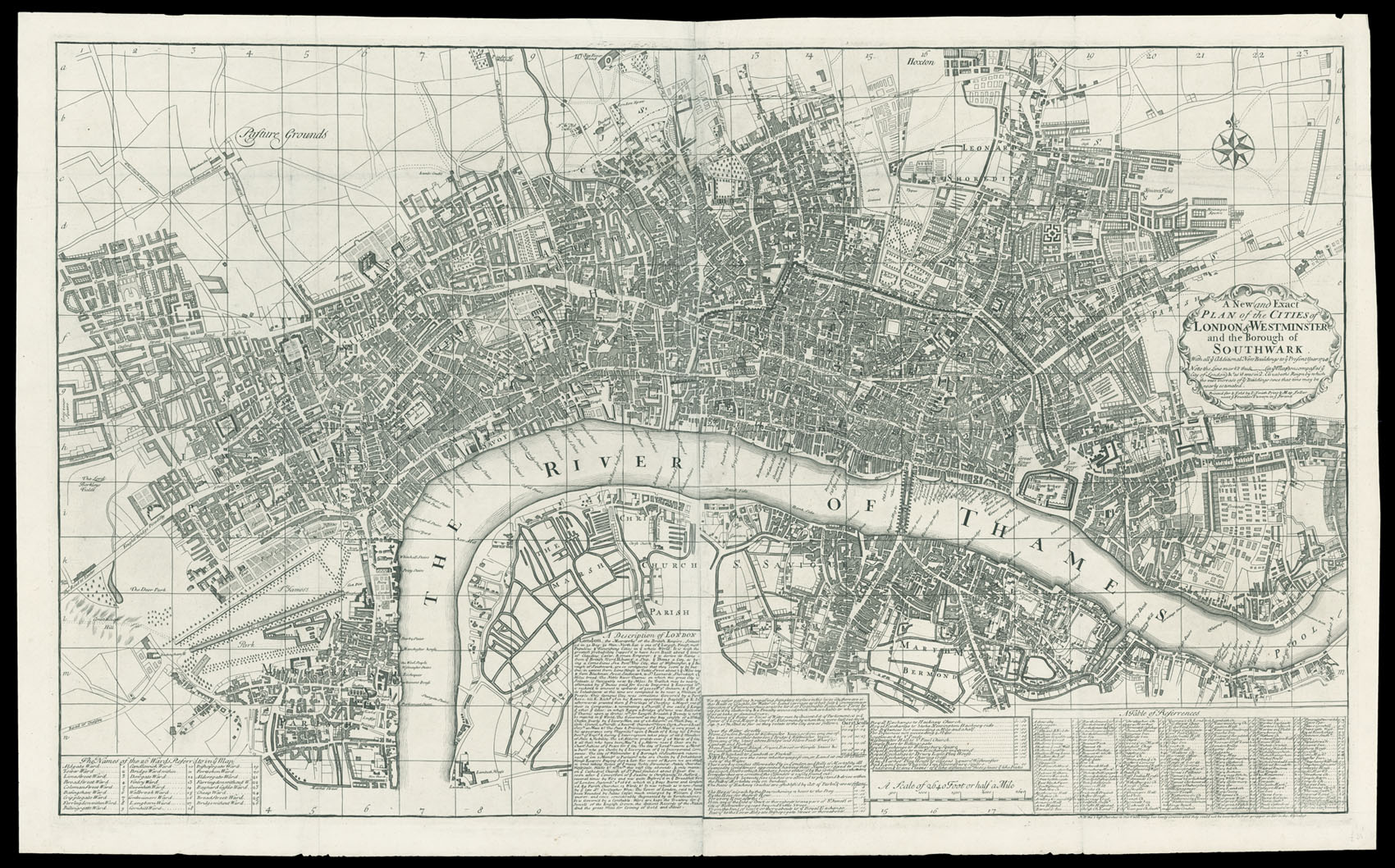
A New and Exact Plan of the Cities of London & Westminster and the Borough of Southwark with all ye Additional New Buildings to ye Present Year 1725.
- Author: SMITH, Joseph
- Publication place: London
- Publisher: Printed for & Sold by I. Smith, Print & Map Seller next ye Fountain Tavern in ye Strand
- Publication date: 1725.
- Physical description: Engraved plan, on two sheets joined.
- Dimensions: 630 by 1030mm (24.75 by 40.5 inches).
- Inventory reference: 1489
Notes
Large and detailed plan of early eighteenth century London.
The plan bears grid lines for ease of reference; the title appears to the right of the plan in a fine cartouche. Many of the most prominent public buildings are shown in elevation, including Lincoln’s Inn, St Paul’s, Temple, Somerset House, and Burlington House. The plan shows much of the new West End development including Grosvenor Square, Mount Street, and Cavendish Square. Below the plan is a description of London, watermen and hackney coach rates, and a list of important public buildings and streets with their grid reference. The rates for watermen are given for both ‘oars’ (a two man boat) or Sculls (single man); the hackney cabs are said to number 800 and are allowed to “Ply in London” and “Bills of Mortality”, all licenced cabs bear a number on the coach door.
This edition appears in Joseph Smith’s edition of the ‘Nouveau Theatre de la Grande Bretagne’, Vol. III, the title page of which bears the date 1724.
Scale: 10 inches to 1 statute mile.
Bibliography
- Howgego 71 (2).
Related items


Sign up to hear about our latest acquisitions, exhibitions and events
Find Us
New York
PO Box 329, Larchmont, NY, USA
Opening hours, London Gallery
Monday to Friday: 10:00 – 18:00
Saturday: by appointment
Closed: all bank holidays and 1-31 August
Opening hours, New York
By appointment only