

Blaeu's Grand Atlas
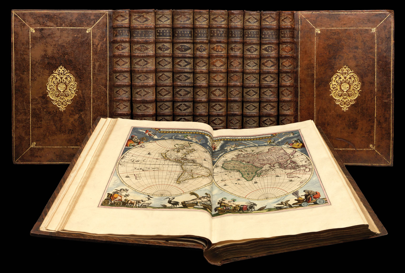
Atlas Major Sive Cosmographia Blaviana, qua solum, salum, coelum accuratissime describuntur.
- Author: BLAEU, Johannes
- Publication place: Amsterdam
- Publication date: 1665.
- Physical description: 11 volumes, folio (540 by 340mm), engraved allegorical or architectural frontispieces, printed titles with engraved vignettes and divisional half-titles, 593 engraved maps and plates, mostly doublepage (some folding), extra-illustrated with 28 engraved maps, engraved illustrations, coloured throughout in a contemporary hand, heightened in gold, eighteenth-century calf over boards, gilt double-fillet border, gilt rolltooled inner panel with fleurons at each inner corner, large gilt lozenge shaped centrepiece incorporating acanthas leaves and a central globe device, spine gilt in compartments, gilt lettered, gilt edges, each volume housed in custom-made slipcases.
- Inventory reference: 1984
Notes
Large paper copy of 'the greatest and finest atlas ever published' (Koeman).
The 'Atlas Major' in its various editions was the largest atlas ever published. It was justly famed for its production values, its high typographic standard, and the quality of its engraving, ornamentation, binding and colouring. The atlas frequently served as the official gift of the Dutch Republic to princes and other authorities. It is one of the most lavish and highly prized of all seventeenth-century illustrated books.
The maps are embellished in the Baroque style, and many rank among the most beautiful ever made. Of particular note are the famous side-panelled maps of the continents, the 58 maps devoted to England and Wales (vol. 4 ), Martini's Atlas of China, the first atlas of China published in Europe (vol. 9 ), and a series of 25 maps of America, including important early maps of Virginia and New England (vol. 8 ).
Contents
Volume I World, Europe and Scandinavia. 61 maps and plates, extra illustrated with 2 maps by de Wit: 'nova orbis tabula in lucem edita' between g2 and g3 of the preliminary section and 'nova et accurata totius Europae descriptio' between a2 and
b1 of the Europe section, lacking text leaf with 'admonitio de origine ducatus Slesvicensis', some light marginal staining.
Volume II Northern and Eastern Europe. 39 maps and plates, extraillustrated with 8 maps: 'novissima Russiae tabula' by Isaac Massa between a2 and b1 of the Russia section; 'Ukrainae pars quae Barclavia Palatinatus' (slightly stained), 'Ukrainae pars quae Kiovia Palatinatus', 'Ukrainae pars quae Pokutia', 'Ukrainae pars quae Podolia Palatinatus', all by Guillaume Le Vasseur de Beauplan, between r1 and s1 of the Poland section; 'Illyricum Hodiernum' by Blaeu between q2 and R1 of the Southeastern Europe section; 'exactissima totius Archipelagi nec non Graeciae tabula' by Nicolas Visscher between a2 and b1 of the Greece section; 'nova et accurata Moreae olim Peloponnesus dictae delineatio' by Blaeu between g2 and h1 of the Greece section, lacking second letterpress title-page, lacking dedication to Czar Alexei,
couple of small marginal holes (not affecting text), map of 'Hungaria Regnum' slightly stained, several leaves browned.
Volume III Germany. 96 maps (3 folding), extra-illustrated with 8 maps: 'circuli Austriaci pars septentrionalis' between f2 and g1, 'regnum Bohemia' between i2 and k1 (upper right hand corner creased), 'circulus Bavaricus' between 2l2 and 2m1, 'circuli Saxoniae superiori' between 2q2 and 2r1, 'marchionatus Brandenburgi et ducatus Pomeraniae' between 3d1 and 3e1, 'circulus Saxoniae inferioris' between
3q2 and 3r1, 'Leodiensis episcopatus' between 5r2 and 5r3, 'utriusque Alsatiae ducatus Dupontii et Spirensis episcopatus' between 7b1 and 7c1, all by de Wit save the penultimate map which is by Visscher, closed tear to lower margin of folding
map of the Rhine, some offsetting from maps, browning to some leaves.
Volume IV The Low Countries. 63 maps, extra-illustrated with a map 'Belgii regii tabula' by Visscher between f1 and a1, some light staining.
Volume V England and Wales. 58 maps, extra-illustrated with a map 'Anglia regnum in omnes suous ducatus' by de Wit between v2 and x1, lacking 2v1 and 2 (two pages of text and the map of Surrey), replaced by an unsigned map of Surrey, verso blank.
Volume VI Scotland and Ireland. 55 maps, light staining to some inner margins affecting a few maps.
Volume VII France and Switzerland. 69 (of 70) maps, pp. 123 and 124 printed on separate sheets, map 50 in the very rare state of having the signature 4l and some text on p. 209, lacking map 55 ('La Bresse Chalonnoise'), not called for in index and
often not present, some browning.
Volume VIII Italy. 60 maps, extra-illustrated with 3 maps by de Wit: 'accuratissima dominii Veneti in Italia' between 2a 2 and 2b 1, 'status ecclesiasticus et magnus ducatus Thoscanae' between 2v 2 and 2x 1, 'regnum Neapolis' between 4c 2 and 4d 1, some browning.
Volume IX Part 1. Spain and Portugal. Part 2. Africa. 41 ( 28 + 13) maps and plates, including 3 folding, extra-illustrated with 2 maps by Visscher: 'Hispaniae et Portugalliae regna' between a 2 and b 1, 'Portugalliae et Algarbiae regna' between 2i 2 and 2k 1, map 1 ('regnorum Hispaniae nova descriptio') creased at centre, map 34 ('Nigritarum regio') with a repaired closed tear, map 40 ('insulae promontori viridis') torn with corner loss (not affecting map).
Volume X Asia. 28 maps, extra-illustrated with 3 maps, 'accuratissima totius Asiae tabula' between a 2 and b 1 and 'nova Persia Armerniae, Natoliae et Arabiae descriptio' between d 2 and e 1, both by de Wit; 'terra sancta' between l 2 and m 1
by Visscher, some offsetting from maps, heavy spotting.
Volume XI America. 23 maps, map 1 ('Americae nova tabula') creased, map 17 ('sinus omnium sanctorum') loose.
Provenance
Provenance
1. Baron de Karg, note on pastedown of volume 1 and signature on title page of volume 2, probably Friedrich Karl Baron Karg von Bebenburg, the Lord of Reichenstein-Schönsee from 1760 to 1797
2. Johann Adam von Reisach of Monheim (1765– 1820), suicidal bibliophile, bought from the Bibliotheca Kargianae on 16 May 1796, signature and 'ex bibliotheca Reisachiorum' inscriptions in each volume.
Bibliography
- Brotton, 265-290
- Van der Krogt
- S. Kramer, 'Ex bibliotheca Reisachiorum', Scriptorium 34 (1980), pp.91-95
- Shirley, British Library.
Image gallery
/
 Rare Maps
  Rare Atlases
  Rare Books
  Rare Prints
  Globes and Planetaria


