 地图
地图  地图集
地图集  珍本
珍本  版画
版画  天文仪器
天文仪器 注册以了解我们最新的收购、展览和活动


地址
纽约
PO Box 329, Larchmont, NY, USA
开放时间,伦敦画廊
周一至周五:10:00-18:00
周六请预约
公休日:所有银行假日以及 8月1日至31日
营业时间,纽约
仅限预约

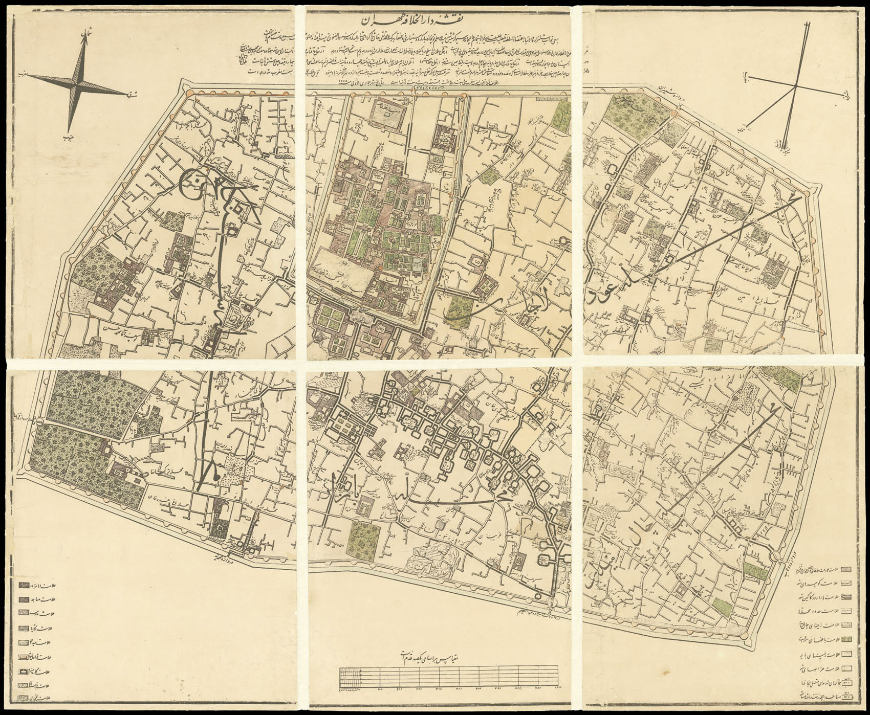
[Plan of Tehran]
- 作者: KRIZIZ, August
- 出版地: [Tehran
- 发布日期: 1859].
- 物理描述: Hand-coloured lithograph plan, dissected and mounted on linen, minor loss to a few sheets.
- 方面: 800 by 970mm (31.5 by 38.25 inches).
- 库存参考: 1121
笔记
‘The map shows Tehran within the walls built by Shah Tahmasb in 1515 and restored by Aqa Mohammad Shah Qajar on his accession. It represents the traditional city, where the main social elements, court, Tojjar (merchants), Asnaf (artisans) and Ulama (clergy) are reflected in the structure of the city in the Ark or citadel, Bazar and Mosque’ (Alemi)
Tehran covered a mere four square kilometers at the time plan was drawn in 1859, and housed a population of only 100,000. The city would later, in the 1870s under the rule of Nasir al-Din Shah, be substantially remodelled along European lines, most notably to echo that of Paris, which the Shah was said to have fallen in love with.
The plan was part of the rapid Europeanisation that would transform Tehran over the next fifty years. It was produced in the Dar-ol Fonum – the polytechnic school, founded along western lines in 1851 – under the supervision of an Austrian artillery officer, Major August Kriziz, who had taken up a teaching post at the school. He was aided in his endeavour by Qajar prince Ali Quli Mirza I’tizad al-Saltana and two of his students, Zulfiqar Beg and Muhammad Taqi Khan Shakir, who helped him access places which would have been forbidden to a European. The text that surrounds the plan gives details about Tehran’s precise location, duration of the longest and shortest days, altitude in ‘French meters’, average temperature, and acceleration of gravity.
参考书目
- Alemi, Mahvash."The 1891 Map or Tehran: Two cities, two cores, two cultures." Environmental Design: Journal of the Islamic Environmental Design Research Centre 1 (1985): 74-84.
相关项目


请注册以了解最新珍品、展览和活动信息
地址
纽约
PO Box 329, Larchmont, NY, USA
开放时间,伦敦画廊
周一至周五:10:00-18:00
周六请预约
公休日:所有银行假日以及 8月1日至31日
营业时间,纽约
仅限预约