 地图
地图  地图集
地图集  珍本
珍本  版画
版画  天文仪器
天文仪器 注册以了解我们最新的收购、展览和活动


地址
纽约
PO Box 329, Larchmont, NY, USA
开放时间,伦敦画廊
周一至周五:10:00-18:00
周六请预约
公休日:所有银行假日以及 8月1日至31日
营业时间,纽约
仅限预约

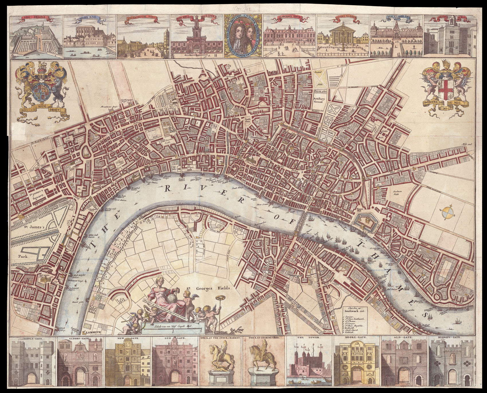

Rare plan depicting London during the reign of William and Mary
[London].
- 作者: ANONYMOUS
- 出版地: [?Amsterdam,
- 发布日期: c. 1690].
- 物理描述: Hand-coloured engraved plan, with 18 inset views of major public buildings, gates, and statues, a few nicks and tears skilfully repaired.
- 方面: 485 by 595mm (19 by 23.5 inches).
- 库存参考: 1513
笔记
This highly detailed plan extends from Westminster in the west to Wapping in the east and Clerkenwell in the north to St. George's Fields in the south. The most important public buildings are depicted in elevation, including the Tower of London, Westminster Abbey, and St Paul's. Several places are marked with letters and numbers. To the left of St George's Field is a reclining female, with a globe and pair of compasses; she sits upon the scale bar and is surrounded by putti holding surveying tools. To the upper left and upper right are the royal and City of London coats-of-arms respectively. Above and below the plan are eighteen views of public buildings, gates, and statues; they are from upper left to lower right: The Temple (Temple Bar), Whitehall, Westminster Hall, The Royal Exchange, Clarendon House, Covent Garden, New Bedlam, Bridewell, Cripple-gate, Alders-gate, Newgate, Ludgate, Statue of Charles II at the Stocks Market, and Charles I at Charing Cross, The Tower of London, Moore-gate, Ald-gate, and Bishops-gate. Also along the upper border is a cameo of William and Mary.
Scale: approx. 6 inches to 1 statute mile.
Scale: approx. 6 inches to 1 statute mile.
参考书目
- Howgego 39.
图片库
相关项目


/
请注册以了解最新珍品、展览和活动信息
地址
纽约
PO Box 329, Larchmont, NY, USA
开放时间,伦敦画廊
周一至周五:10:00-18:00
周六请预约
公休日:所有银行假日以及 8月1日至31日
营业时间,纽约
仅限预约