购物车里没有产品
返回商店
地图 地图集 珍本 版画 天文仪器
在此您可以通过视频、播客和虚拟现实之旅,来了解我们的地图、地图集和书籍背后的故事。
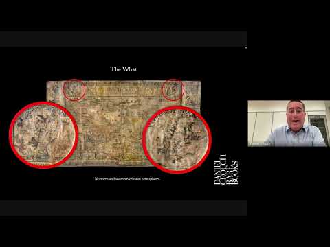
In 2011 Daniel Crouch Rare Books acquired the only surviving complete example of Luis Teixeira’s 1604 Magna Orbis Terrarum Nova. In 2015 another copy came to light. Monumental seventeenth century wall maps, it appears, are like London buses: you wait 400 years, and then two come along at once!
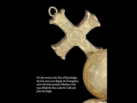
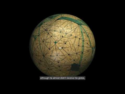
A newly-discovered sixteenth century rosary telling the story of creation and the early ages of man. Only the second known example of such an extraordinary devotional object, the Boncompagni Rosary features two miniature globes. These celestial and terrestrial spheres, bearing many of the hallmarks of contemporary cartography and astronomy, are part of a globe-making tradition that spanned Europe during the sixteenth and seventeenth centuries.
Carletti’s ambitious project was spurred by the urban reform brought about by the new ruler of Naples, Charles of Bourbon, who had been installed as King of the Two Sicilies in 1734. The last accurate map of Naples had been made by Antonio Lafreri in 1566 — it was high time for another. The civic tribunal of San Lorenzo agreed to finance the map in 1750, although the project took a quarter of a century to complete.
The story of London told in 30,000 books, maps, and prints spanning 400 years.
In 1675, the same year that De’ Rossi secured the prestigious and valuable commission of decorating the papal summer residence, the Castel Gandolfo, with nearly two hundred engraved maps of Europe, America and the city of Rome, he also created this magnificent and elaborate wall map of the world, published with the privilege of the Pope.
Daniel Crouch took part of this year’s Malcolm Young Lecture, which is the Society’s annual lecture given in honour of Malcolm Young, co-founder of IMCoS.
California Map Society Spring Conference – Day One (1 May 2021)
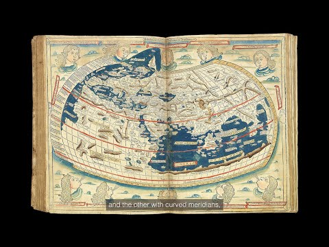
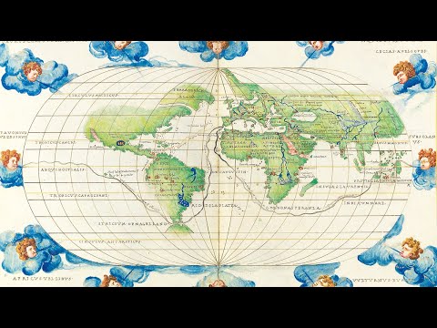
Claudius Ptolemaeus (Ptolemy) has been called the father of geography.
The Greek astronomer and cartographer was born and lived in Alexandria in Egypt between c100 and 170.
A rare and fascinating manuscript globe of Mars made during a period of renewed interest in the red planet and suggestive of the possibility of Martian civilisation.
One of the finest maps of – what is now – Greater London ever produced.
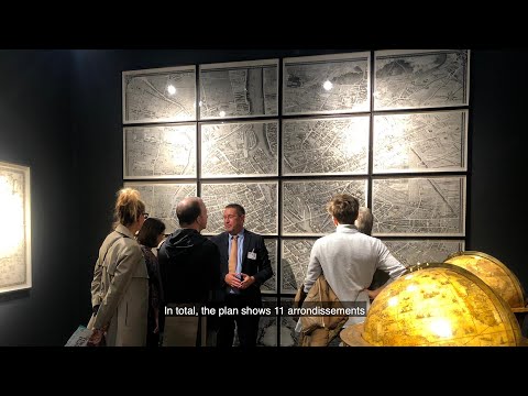
Turgot’s fine plan of Paris during the reign of Louis XV.
In 1734 Michel-Étienne Turgot (1690-1751), Mayor of Paris, decided to promote the reputation of Paris to Parisian, provincial and foreign elites by implementing a new plan of the city. He asked Louis Bretez, a member of the Royal Academy of Painting and Sculpture, and professor of perspective, to draw up the plan of Paris and its suburbs.
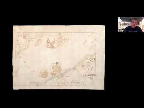
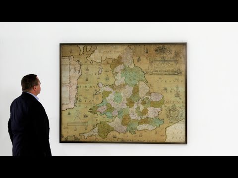
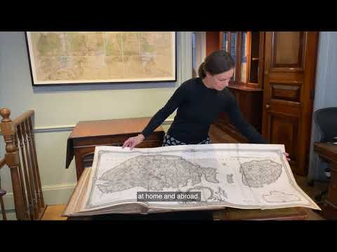
Christopher Saxton’s wall map is a result of the first survey of the whole of England and Wales, and is the first map of those countries to give all the place names in English. Saxton has been dubbed “the father of English cartography” (Skelton).
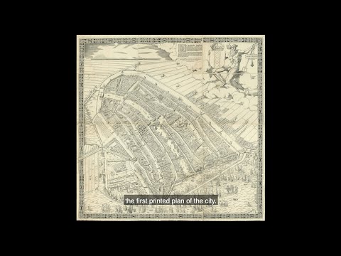
The map shows the city of Amsterdam in the early decades of the sixteenth century, facing south, before the construction of the semi-circular ring of canals. It is bordered by the IJ, the Singel, a stretch of river Amstel, in the west and the Kloveniersburgwal and Gelderse Kade in the east. The waterway in the middle is labelled here “Den Amstel” in the South and “Damrack” in the North.
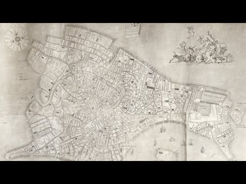
One of the largest maps of Venice ever published, and the first map of the city based upon accurate field surveys. Lodovico Ughi’s topographical map is a landmark in the cartographic history of Venice. Successive Venetian mapmakers in general did not significantly alter the appearance of the city: among the exceptions is Ughi’s work. Not only is it one of the largest printed plans of Venice, but it also served for centuries as a model for subsequent maps.
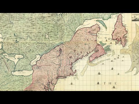
Popple’s 20 sheet ‘Map of the British Empire in America’ is one of the two most important large format maps of North America published in the eighteenth century. Along with John Mitchell’s ‘Map of the British & French Dominions in North America’, the map was a profound statement of England’s designs for dominance of the North American continent; at a time when colonial control of North America was by no means certain.
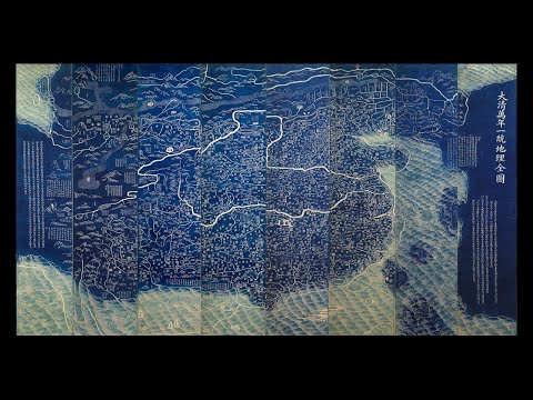
An extraordinarily rare cartographic document that is based on research originally presented to the Qianlong emperor by Huang Qianren (fl. 1760- 70) in 1767. The title of the map is as much a political programme of the Qing as it is a geographical record. It shows China at the height of the Qing empire, celebrating the “unified status of all of Chinese borders” (Pegg).
A monumental Chinese celestial chart Huntian yitong xingxiang quantu, one of the largest planispheres published during the Qing dynasty (1636-1912). The work combines both Chinese and Western astronomy, highlights the fundamental role that knowledge of the heavens played in Chinese politics, and illustrates the Qing dynasty’s endeavours to seek authentic truth in ancient texts.
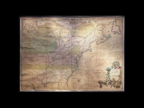
Mitchell’s map is widely regarded as the most important map in American history. Prepared on the eve of the Seven Years’ War (or French and Indian War), it was the second large format map of North America printed by the British (the first being Henry Popple’s map of 1733), and included the most up to date information of the region: “the result of a uniquely successful solicitation of information from the colonies” (Edney). Over the following two hundred years, it would play a significant role in the resolution of every significant dispute involving the northern border of the then British Colonies and in the definition of the borders of the new United States of America.
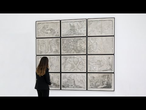
The finest of the eighteenth century plans of Rome and the first plan of the city based upon geodetic principles.
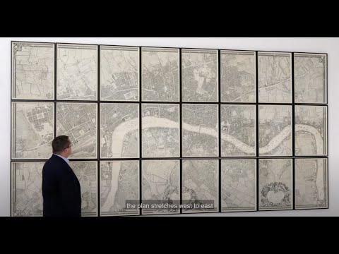
Printed on twenty-four sheets of paper and measuring some two by four metres, Rocque’s 1746 map is the first large-scale survey of the cities of London, Westminster, and Southwark.
Incredible in both scale and detail, the plan stretches west to east from Hyde Park to Limehouse and north to south from New River Head to Walworth.
For the 2020 online edition of Frieze Masters, we are delighted to dedicate our exhibition to a rarely celebrated art form: the eighteenth century baroque town plan.
The town plans of the eighteenth century reveal developments in urban cartography and reflect a new, planned, shape for the world’s great cities. These ‘new’ cities significantly restructured the historic medieval and Renaissance centres and greatly expanded the built-up area.
‘Baroque’ town planning in European cities answered the needs of the grandiosity demanded by the megalomania and triumphalism of the absolutist monarchies of the time, as well as the demographic changes that had to be faced.
The collection comprises massive wall maps of Amsterdam, Berlin, London, Madrid, New York, Paris, Rome, and Venice.
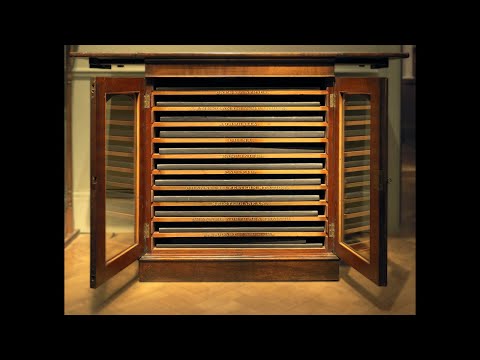
A chart case from the Her Majesty’s Yacht Victoria and Albert (II), containing 284 charts, covering the entire globe, and demonstrating The British Admiralty’s mastery of the seas at the height of the British Empire.
The chart case contains 10 pilots providing detailed charts for navigation from the British Isles to: Africa and the Cape of Good Hope; North America and the West Indies; Australia; China; The East Indies; The Pacific; The English Channel and Ireland; The Mediterranean; The English Channel, North Sea and Baltic; and The South East Coast of South America. Ranging from 30 charts contained in the China pilot to a mere 14 charts in the Africa pilot.
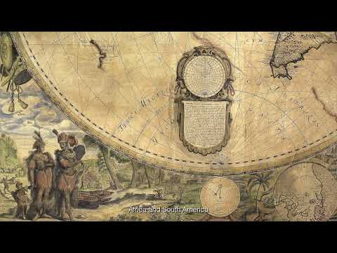
A spectacular wall map of astonishing beauty made at the beginning of the Dutch Golden Age.
The present map draws on the cartography of Luis Teixeira (fl.1564-1613) – whose name appears in the large pasted title – a Portuguese cartographer from a famous mapmaking dynasty. He worked in Lisbon and the Portuguese colonies, but was also a friend of and collaborator with Dutch cartographers, contributing a map of Japan to Abraham Ortelius’ atlas. Ortelius and Cornelis Claesz published five of his maps between them, and all were specifically advertised as based on his work, indicating that he was highly respected in Amsterdam.
The map is based upon a simple cylindrical projection and follows very closely the 1592 wall map drawn by Petrus Plancius, “a milestone in the emergence of Dutch cartography [and] the first large wall map of the world to be published in the north” (Schilder).
Louis (1729–1765) was the only surviving son of King Louis XV of France and his wife, Queen Marie Leszczyńska. Son of the king, Louis was styled Fils de France, and as heir apparent, he became Dauphin of France. However, he died before ascending to the throne. Three of his sons became kings of France: Louis XVI (reign: 1774–1792), Louis XVIII (reign: 1814–1815; 1815–1824) and Charles X (reign: 1824–1830).
The atlas covers Italy, Sicily, Sardinia, Corsica, and Malta. The maps range in date from 1653-1753, with the majority dating from the first half of the eighteenth century. All but three maps (two by Homann and one by the Spanish cartographer Chafrion) are by the leading French cartographers of the day, these include De Fer, Jaillot, Delisle, Du Val, Le Rouge, and Nolin.
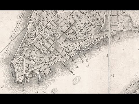
“Perhaps the finest map of an American city and its environs produced in the eighteenth century” (Augustyn).
The new plan, first published in 1770, lays out a city of about 25,000 inhabitants and its surrounding farmland. It offers a remarkably accurate view of the streets of lower Manhattan and depicts the farms, roads and topography reaching to approximately present day 50th Street; along with the marshy New Jersey shores of the Hudson; Kennedy, Bucking and Governors Islands; and parts of present day Brooklyn along the East River. The map is paired with an idyllic panoramic view of the city from Governors Island.
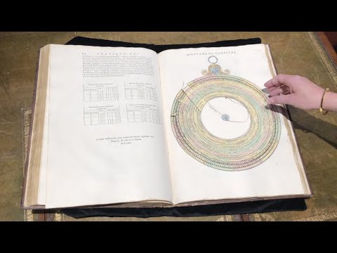
First edition of the Scotsman James Bassantin’s (c1500-1568) copiously illustrated, large-format compendium on calculating planetary positions. From the library of Mary, Queen of Scots, bound in Paris with her crowned initial, and with all the illustrations in fine contemporary hand-colour.
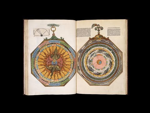
“The most spectacular contribution of the book-maker’s art to sixteenth-century science” from the library of Grand Duchess Maria Nikolaevna of Russia.
This atlas is in its original Agnese binding, and it can confidently be stated that the order of the sheets is just as Agnese originally produced it: it contains the more or less standard preliminary pages found in most Agnese atlases, including a table of the declination on the sun, an armillary sphere, and a circular zodiacal calendar.
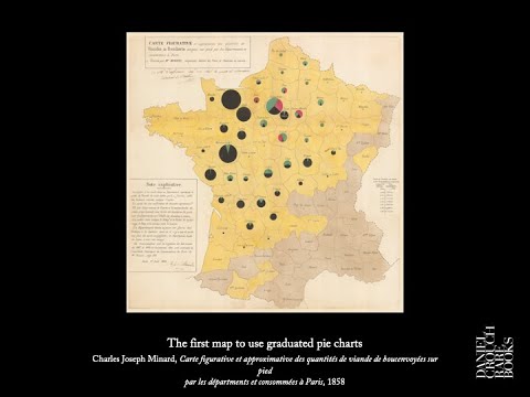
Daniel Crouch talks about the earliest and greatest exponents of cartographic data visualization as part of the lecture series portion of the San Francisco Map Fair 2018.
Celebrating our fifth anniversary, we hope you enjoy the video and soundtrack, which has been specially written for the occasion by our favourite New York band: Tin Pan.
London map expert Daniel Crouch lectures on the Ricci map at the MIA. This lecture is co-presented by the Minneapolis Institute of Art, the Associates of the James Ford Bell Library and the James Ford Bell Library of the University of Minnesota Libraries.
地图
地图集
珍本
>版画
天文仪器