 地图
地图  地图集
地图集  珍本
珍本  版画
版画  天文仪器
天文仪器 注册以了解我们最新的收购、展览和活动


地址
纽约
PO Box 329, Larchmont, NY, USA
开放时间,伦敦画廊
周一至周五:10:00-18:00
周六请预约
公休日:所有银行假日以及 8月1日至31日
营业时间,纽约
仅限预约


The Great Exhibition
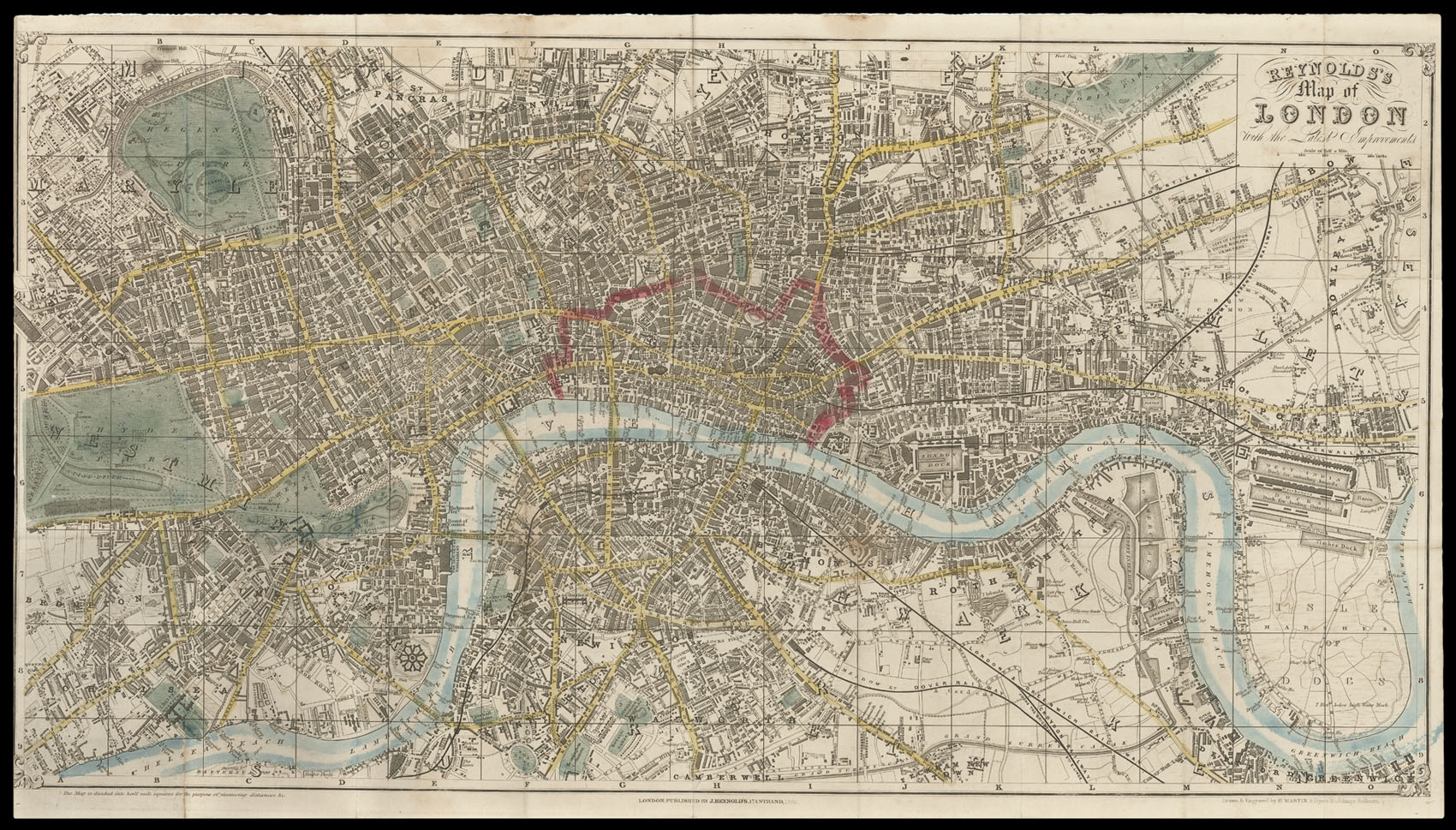
Reynolds's Map of London with the Latest Improvements.
- 作者: REYNOLDS, James
- 出版地: London,
- 出版商: J. Reynolds, 174 Strand,
- 发布日期: 1851.
- 物理描述: Hand-coloured engraved folding map, 'Drawn and Engraved by H. Martin, 8 Dyers Buildings, Holborn'; a few old tears but generally an attractive map, together with the booklet of 22, [14] with an inserted outline map of "exhibition Chief Objects of Interest in London"; folding into original cloth boards, the upper cover with a green printed label 'The Exhibition Map of London and Visitors Guide. price 1s 6d Colored.'
- 方面: 435 by 770mm (17.25 by 30.25 inches).
- 库存参考: 1571
笔记
An attractive map and guide to London produced for visitors during the Great Exhibition.
The plan shows the Crystal Palace, which occupies a large part of the southern portion of Hyde Park. Railways and are clearly marked in black with main roads coloured yellow, open spaces in green, and the City of London outlined in red. A booklet accompanies the map, which contains a great deal of information for the 'Stranger' to London. It advises him that he must be "vigilant and circumspect... lest he become the prey of some of the swarms of knaves". After frightening the poor tourist half to death, the guide goes on to list the various amusements and sights the city has to offer. Most notable among its attractions is the Great Exhibition, which if one wishes to go to the opening day will cost a gentleman £3 3s and a lady £2 2s.
Scale: 4 inches to 1 statute mile.
参考书目
- Howgego 406 (3).
图片库
相关项目


/
请注册以了解最新珍品、展览和活动信息
地址
纽约
PO Box 329, Larchmont, NY, USA
开放时间,伦敦画廊
周一至周五:10:00-18:00
周六请预约
公休日:所有银行假日以及 8月1日至31日
营业时间,纽约
仅限预约