 地图
地图  地图集
地图集  珍本
珍本  版画
版画  天文仪器
天文仪器 注册以了解我们最新的收购、展览和活动


地址
纽约
PO Box 329, Larchmont, NY, USA
开放时间,伦敦画廊
周一至周五:10:00-18:00
周六请预约
公休日:所有银行假日以及 8月1日至31日
营业时间,纽约
仅限预约


The birth certificate of Poyais
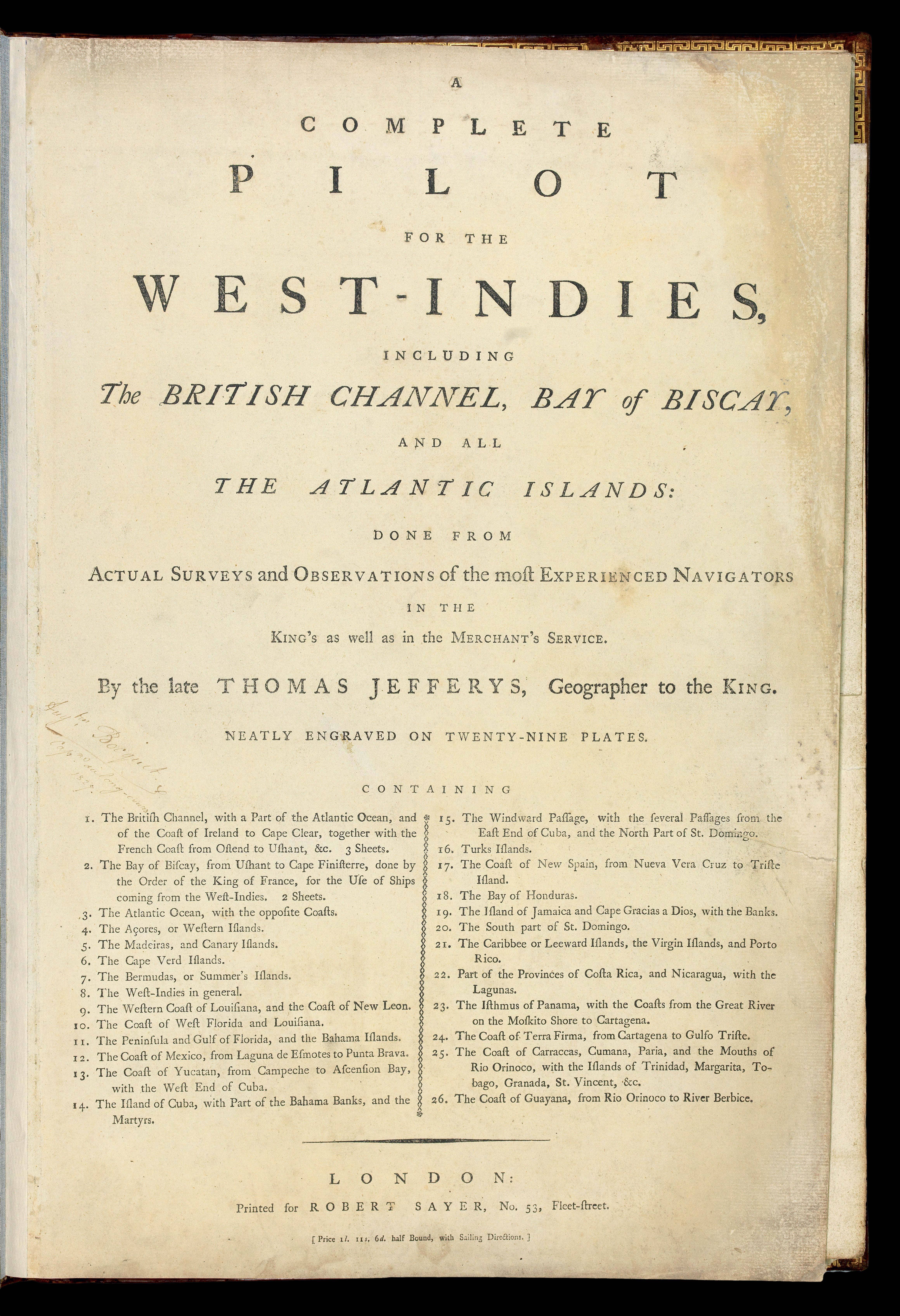
A Complete Pilot for the West-Indies...
- 作者: JEFFERYS [Thomas]
- 出版地: London,
- 出版商: Printed for Robert Sayer, No. 53, Fleet Street,
- 发布日期: [c1792].
- 物理描述: Large folio (540 by 370mm), title, 26 engraved charts (two folding, one single sheet, the rest double-page), contemporary full diced calf, skilfully rebacked, gilt spine in six compartments, gilt text on morocco label.
- 库存参考: 12156
笔记
Rare edition of Jefferys's 'West Indian Atlas' featuring the fictitious country of Poyaisia - the subject of an elaborate and audacious fraud by the improbably named Gregor MacGregor.
The Poyaisian Scheme
The Poyaisian Scheme (or Fraud) was the brainchild of the Scottish soldier Gregor MacGregor (1786-1845). He began his life of adventuring in Venezuela and Colombia as a mercenary fighting alongside Simone de Bolivar. In 1820 he visited what is today Honduras, and claimed that, while there, he obtained a grant of eight million acres (12,500 square miles) of fertile land from George Frederick Augustus, King of the Mosquito Indians. Returning to London, Macgregor styled himself as Gregor I, Cacique (highest authority or prince) of the independent state of Poyais. He set about publicising his fictitious state, setting up a land office in London and selling bonds to investors. The scheme began to unravel when, echoing the Darien scheme of the late seventeenth century, a group of around 200 settlers, mostly Scots, sailed to Poyais. Discovering only a barren and inhospitable swampland, they were saved by a British rescue mission. MacGregor fled to Paris in late 1823 only to continue his activities there. After acquittal in a French fraud trial he returned to London in 1827. He would continue to perpetuate the fraud until 1836, when he issued a constitution for the county. He would later emigrate to Venezuela, where he lived out the rest of his life in relative comfort on a military pension from the Venezuelan state. MacGregor's eventful life, and the story of Poyaisia, is eloquently chronicled by David Sinclair in 'Sir Gregor Macgregor and the Land That Never Was: The Extraordinary Story of the Most Audacious Fraud in History'.
The Atlas
First published in 1778, Jefferys's 'West India Atlas' was designed to aid the highly lucrative sugar trade, which by this point accounted for around one-fifth of all imports to Europe, 80 percent of which was supplied by French and British colonies in the West Indies.
Unfortunately, Europe's insatiable desire for sugar drove a viler – although no less lucrative – trade: that of the trafficking of slaves from the west coast of Africa to the Caribbean plantations. It is estimated that by the time the atlas was published, some 400,000 enslaved people were at work in the British Caribbean colonies.
Unfortunately, Thomas Jefferys would not live to see the publication of his 'West Indian Atlas', and it was left to Robert Sayer who, in partnership with John Bennett, acquired his materials and published the atlas posthumously under Jefferys's name. The work was evidently a commercial success as there were five subsequent editions under the Sayer and Bennett imprint. In 1794 an expanded and modified version with 61 plates was published under Sayer's sole imprint. In the same year Laurie & Whittle acquired Sayer's plates, and they published a further version with the same title page, but with their imprint.
The present atlas, is titled 'A Complete Pilot of the West Indies'. This form of the work, containing just the charts, was first issued in 1778, as the 'Neptune Occidental: A Complete Pilot of the West Indies'. In the current work, the title has been reset, bears Sayer's imprint alone, and should be dated to around 1792, just before he was to sell the plates to Laurie and Whittle.
The Map
In 1732 a modest British settlement was established on the coast around the Black River (now the Río Sico) by a British colonist named William Pitt (probably a distant relative of the British politician William Pitt the Elder). This settlement was evacuated following the Anglo-Spanish Convention of 1786. On all versions of Jefferys' map, the north eastern coast of Honduras includes the legend "English Settlements". However, in the c1792 'A Complete Pilot for the West-Indies...' only, the index map to the 16 sheet chart of the West Indies, bears the legend "Poyers" on the "Mosquito Shore". In the same atlas, on sheet 10 of the larger scale map, the text "Popyas or Poyais improperly Poyers" is engraved in the same style as tribal names, and the word "Poyers" is written several times. These toponyms appear in an area that is roughly a triangle with its corners at Cape Gracias a Dios, Cape Camarón and the Black River's headwaters - the same area (roughly the size of Wales) claimed by Gregor MacGregor as Poyaisia, named after the natives of the highlands around the Black River's source, the Paya or "Poyer" people (today called the Pech). The inclusion of "Poyais" on the map of Honduras in the present example is acknowledged by Gregor MacGregor as the source for his own manuscript map of his claim to "Poyaisia" - "the land that never was" - and, it may be reasonably inferred, the source, also, for its name.
参考书目
- British Library Map Catalogue, C.11.d.33
- Gestetner, 30-35
- Sinclair, 'Sir Gregor Macgregor and the Land That Never Was: The Extraordinary Story of the Most Audacious Fraud in History', 2003.
图片库
相关项目


/
请注册以了解最新珍品、展览和活动信息
地址
纽约
PO Box 329, Larchmont, NY, USA
开放时间,伦敦画廊
周一至周五:10:00-18:00
周六请预约
公休日:所有银行假日以及 8月1日至31日
营业时间,纽约
仅限预约