 地图
地图  地图集
地图集  珍本
珍本  版画
版画  天文仪器
天文仪器 注册以了解我们最新的收购、展览和活动


地址
纽约
PO Box 329, Larchmont, NY, USA
开放时间,伦敦画廊
周一至周五:10:00-18:00
周六请预约
公休日:所有银行假日以及 8月1日至31日
营业时间,纽约
仅限预约


By PTOLEMAEUS, Claudius; translated by ANGELUS, Jacobus, and edited by Nicolaus GERMANUS. , 1482
£1,200,000
Cosmographia.
- 作者: PTOLEMAEUS, Claudius; translated by ANGELUS, Jacobus, and edited by Nicolaus GERMANUS.
- 出版地: Ulm,
- 出版商: Lienhart Holle,
- 发布日期: 16 July 1482.
- 物理描述: Folio (428 by 310mm), 102 leaves, double- column, 44 lines and headline, Gothic letter, 32 double-page woodcut maps with fine original hand-colour, 4 woodcut diagrams in the text, 2 large illuminated historiated initials, one showing Donnus Nicolaus presenting his book to Pope Paul II, the other of Ptolemy, 159 other woodcut initials coloured in red, green and ochre, paragraph marks and initial-strokes supplied in ochre, tear to d6, and repaired tear to the map 'Tertia Africa', some dampstaining and discolouration throughout, including spotting affecting the final three maps, skilful reinforcement to weakened lower page corners on maps, single leaf free endpaper bearing ownership inscription; re- cased in contemporary doeskin over clasped oak boards, joints reinforced with vellum waste, remnants of one clasp remaining. [Bound after]: 'Registrum' from Johannes Reger's 1486 edition of Ptolemy's "Cosmographia", decorated with 17 5- and 6-line manuscript initials in red and blue, 30 leaves bound in 6s (not 8s as is usually the case); 9 leaves in the 'registrum' uncut, tear to d6. Collation: [Registrum]: a-d(6), e(5); [Cosmographia]: [i], a10, b-g8, h11, 32 maps. Watermark: Late fifteenth century Italian watermark of a flower with 7 petals throughout, with the exception of the front endpaper/'initial blank', which bears the watermark of an upper case letter 'B' on a crowned shield. These were used by the le Bé family of Troyes, in this case 'Ioane le Bé'. Three members of the Troyenne papermaking le Bé family bore the Christian name 'Jean': Jean I started his business in 1406. Jean II owned two paper mills around the 1470s, and Jean III lived in Troye in the first half of the 16th century. The le Bé family were accredited papermaker for the Université de Paris from 1520 onwards.
- 方面: 414 by 297mm (16.25 by 11.75 inches).
- 库存参考: 17674
笔记
A fine example in a contemporary binding, here bound with Johannes
Reger’s ‘Registrum’ made for his 1486 edition of the work.
The text of Claudius Ptolemy’s (c100-170CE) ‘Cosmographia’ was translated into Latin from the original Greek by Jacobus Angelus (c1360-1411) and was first published, in Renaissance times, at Vicenza
(1475), Bologna (1477) and Rome (1478). The sumptuous edition
published at Ulm in 1482, however, far surpassed all earlier efforts
and remains one of the most important publications in the history of
cartography. This is the first redaction of the “Geography” to be printed
outside Italy, the earliest atlas printed in Germany, the first to depart
from the classical prototype to reflect post-antique discoveries, the first
to be illustrated with woodcuts rather than engravings, and the first to
contain hand-coloured maps, the design and execution of which were
ascribed to a named cartographer, and the first to incorporate the five
modern maps by Nicolaus Germanus (c1420-1490). Though printed
outside Italy, the paper this magnificent atlas was printed on was
imported from Italy, and payment made in part by complete copies of
the finished atlas.
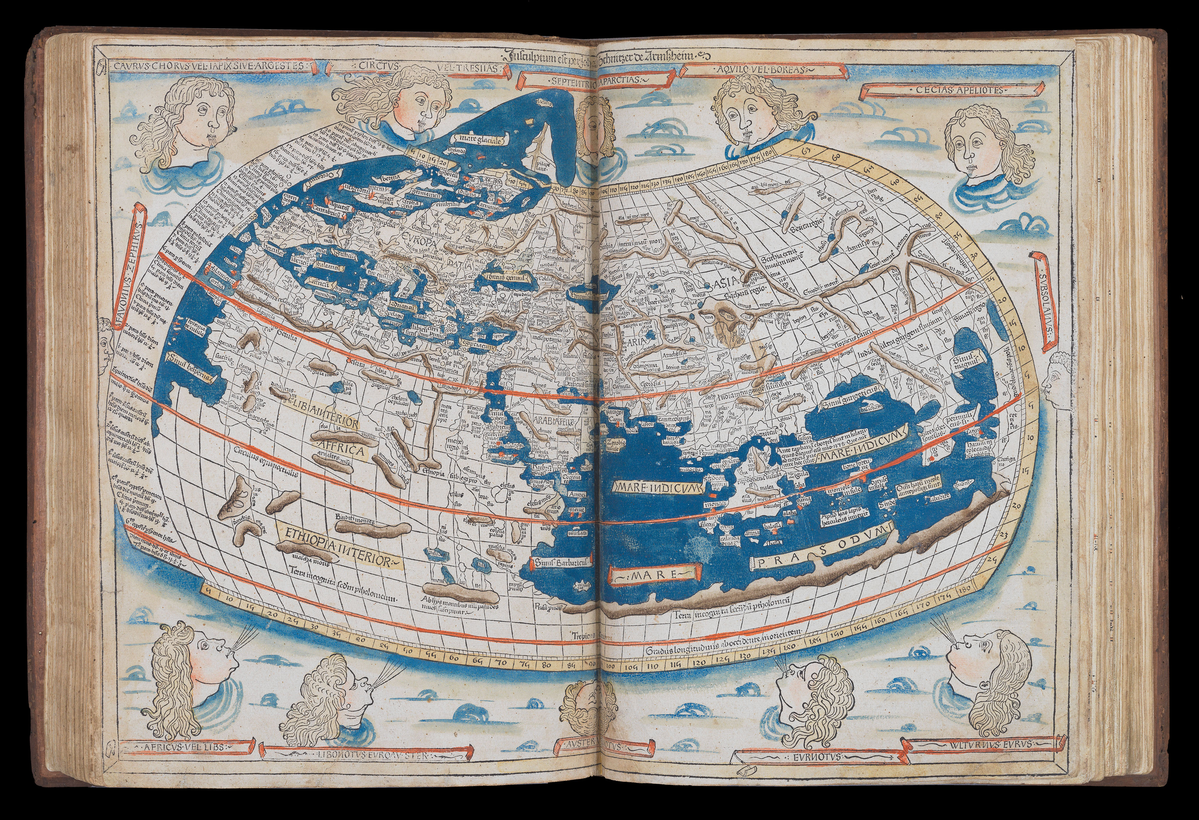
The maps
The 1482 edition is the first printed edition to contain the full complement
of 32 maps, and its world map, extended to the northwest, is the first printed
cartographical representation of Greenland, Iceland and the North Atlantic.
“The artist responsible for the woodcut maps identifies himself at
the top of the world map as Johannes of Arnsheim, making it the earliest
datable printed map to bear a signature” (Campbell p. 137). He has
incorporated as his sign a backwards N into the woodcut text on each map.
The Ulm edition, moreover, was the first to depart from the
classical prototype by expanding the atlas to reflect post-antique
discoveries about the size and shape of the earth. To the canonical
twenty-seven Ptolemaic maps were added five “modern” maps of Spain,
France, Italy, the Holy Land and northern Europe. The world map is
the first to be based on Ptolemy’s second projection, in which both
parallels and meridians are shown curved to convey the sphericity of the
earth. Armszheim, furthermore, updated the Ptolemaic world picture by
incorporating improvements that were probably based on a manuscript
of the 1470s by Nicolaus Germanus (ca 1420-1490), a Benedictine
monk of Reichenbach Abbey in Bavaria, who is depicted in the first
illuminated letter of the atlas presenting his book to the dedicatee Pope
Paul II. One notable addition is a rudimentary depiction of Scandinavia
to the north, within an extension of the map’s top border. This is also the
earliest printed map to show the northernmost reaches of the Atlantic
Ocean. The world map, moreover, embodies what is perhaps the most
readily apparent feature of the Ulm Ptolemy: its beauty.
The text
“The text is the early Latin translation by Jacopo d’Angelo [ Jacobus
Angelus], and its maps are the reworking of the Ptolemaic corpus by the
cartographer Donnus (Dominus) Nicolaus Germanus. Three recensions
of Nicolaus’s reworkings have been distinguished: the first, drawn on a
trapezoid projection reputedly devised by Nicolaus himself and, therefore,
also known as the Donis (Donis = Dominus) projection; the second on a
homeotheric projection and with three additional modern maps; and the
third on the same projection with further revisions and two additional
modern maps. The Ulm Ptolemy derives from the third recension, and
thus represents Nicolaus’s most mature work” (Campbell, ‘Earliest Printed
Maps’, p. 124).
Printing history
“That the stock of the 1482 edition was not exhausted by 1486 is indicated
by the existence of a number of copies (some in early binding) containing
the additional texts printed by Johannes Reger in the latter year for his
own edition…” (Skelton) – The present work is just such a book.
“For Leinhart Holle, the handsome edition of the Cosmographia
which he printed at Ulm in 1482 was an unprofitable investment. Only
one more book came from his press; and by 1484 he was out of business
and gone from Ulm, and his stock of type, blocks, and printed sheets
passed into the hands of Johann Reger, Ulm factor or agent (pro-visor)
to Giusto de Albano, of Venice…
Reger lost little time in bringing the Cosmographia back on the
market. He compiled a gazeteer or geographical index to the text under
the title ‘Registrum alphabeticum super octo libros Ptolemei’, to which he
prefixed a ‘Nota ad inueniendum igitur regiones, explaining its purpose
and use; and he also obtained, or composed, an anonymous tract entitled
‘De locis ac mirabilibus mundi’… they were printed by Reger in 1486 and
inserted into some unsold copies of the 1482 edition… In the map Europa IV in the 1482 edition, Reger found the Ptolemaic name Chetaori, corresponding to his birthplace Kemnat in Bavaria; he introduced this into Ptolemy’s list of towns in bk. II ch. 10 [not present in this 1482 edition of
the main text], and inserted in his ‘Registrum’ the entry: ‘Chemmat siue chetaori li 2 c 10 ta 4 e Hic iohannes reger duxit origine et ano etatis 32 compposuit hoc register in vlma anno domini 1486’. This is the evidence for Reger’s authorship of the ‘Registrum’, which is otherwise unsigned” (Skelton).
Claudius Ptolemaeus
Ptolemy (c100-170), was a Greco-Roman scholar, most famous for the three
works he produced on astronomy, geography and astrology. Almost nothing
is known of Ptolemy’s life save that he lived in Alexandria, and that he was
a Roman citizen, indicated by his Roman nomen of Claudius. He wrote
his most famous work, the ‘Geographia’ around 150 AD, using an atlas by
Marinus of Tyre as the foundation, and adding information from Roman,
Persian and Babylonian sources. Alexandria was an intellectual centre of the
ancient world, and it was also a vital point on trade routes between the Far
East and Europe, giving Ptolemy access to the knowledge of travellers from
all over the empire. The ‘Geographia’ was intended as a supplement to the
‘Almagest’, showing how to put the astronomical principles outlined in the
first work into practice, and providing tables of co-ordinates of important
places throughout the world. What began as a simple list became a synthesis
of classical geographical knowledge from the millennium; Ptolemy collated
and compared every text he could lay hands on. The ‘Geographia’ eventually
ran to eight books. The first was concerned with the practice of geography
and cartography; the middle six were filled with tables of co-ordinates for
over 8,000 locations; and the final book suggested a method of dividing the
oikuomene (the Greek term for the known world) into twenty-six regional
maps: ten of Europe, four of Africa, and twelve of Asia, preceded by one of
the world, for which he offers three projections. This format would be retained in atlases for centuries. Although the ‘Geographia’ gives instructions for the construction of maps, it is unclear whether the original manuscript versions of the text contained any; at any rate, later copyists reconstructed maps from the co-ordinates given in the text, rather than existing examples. The first modern printed edition with maps was not published until 1477 in Bologna
出处
Provenance:
1. inscribed on front free endpaper “Donnait Le Sr. munery mon beaufrere [given by my brother-in-law Sr. Munery] anno 1672 Morel Senator”.
2. inscribed on d2 “Josephus Mattheus de Morel 1718, Franciseii de Morel”.
This is probably André de Morel (Maurel) (1603-1690), Senator in the Parlement de Provence. Morel’s family began their social elevation under Charles d’Anjou (1446-1481) who was also King of Naples and Earl of Provence. It is said that the King put Pierre de Morel in his will and, at his death in 1481, he inherited a part of his library. The family served the French Crown as advisors and officers during wars in Northern Italy and Spain until Henri IV of France. Then in the late 1620’s André de Maurel became a prominent magistrate and member of Parliament of Provence. He ruled his office for 67 years and was known as Senator Morel. His second son, Joseph de Maurel (1658-1717) was Bishop of Saint Paul-Trois-Chatêaux between Aix and Valence. His heir and nephew, François de Maurel, Captain in the ‘Regiment de Toulouse’ in 1719, inherited his belongings after his death.
参考书目
- Campbell, 179-210
- Schreiber, 5032
- Skelton, bibliographical note prefixed to the facsimile of the 1482 Ulm Ptolemy
- Troley, T.2:636.
图片库
相关项目


请注册以了解最新珍品、展览和活动信息
地址
纽约
PO Box 329, Larchmont, NY, USA
开放时间,伦敦画廊
周一至周五:10:00-18:00
周六请预约
公休日:所有银行假日以及 8月1日至31日
营业时间,纽约
仅限预约